GeoBonifiche

Geographic Information System

GeoBonifiche

Geographic Information System

Land Reclamation Consortiums are aknowledged as local authorities for land management and protection. Their goal is to achieve innovation and development for the agricultural industry of the country.

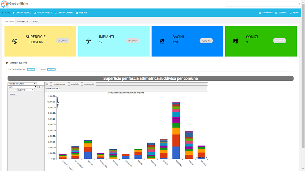
Their vast knowledge about the land and its territories is a crucially important asset.

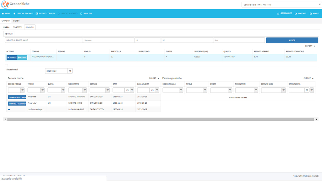
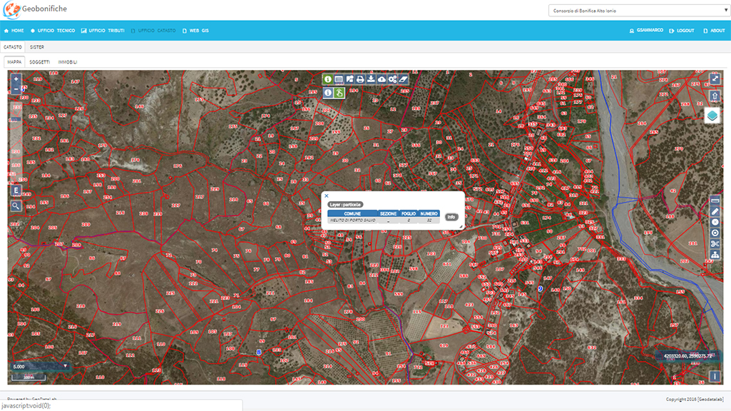
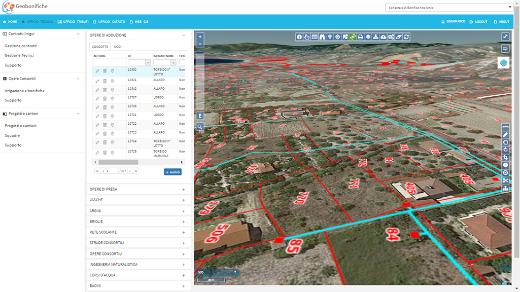
Computerized management of their available data will undoubtedly improve their efficiency and analysis capacity.

GeoBonifiche meets the design, planning and optimization needs of the Land Reclamation Consortiums perfectly.

This module allows you to manage river embankments and weirs, drainage networks, roads, environmental engineering works and reforestation projects.

Every land reclamation work has its own geolocation and maintenance status information enclosed, allowing to quickly analyze presence, quality and benefits indicators of the reclamation activities.

This module allows you to manage water adduction and distribution networks, water intake structures, reservoir tanks and dams.

Every irrigation work has its own geolocation and maintenance status information enclosed.

It is possible to create so called irrigation agreements containing all the details about every land parcel involved and about the frequency and arrangement of the irrigation service distribution and payment.

Charges management and calculation tools for land reclamation works (reclamation roles) and irrigation agreements (irrigation roles).

Using the consortium’s credentials and complying to all the security policies, this module has access to the tax registries of the Internal Revenue Agency and can therefore guarantee that the cadastral databases will always be up to date.

The system provides an exporting tool for the cadastral registries record trackings (the file format is compatible and can be imported into the Internal Revenue Agency’s systems) as well as an importing tool for the files containing the official tax registries available on the Internal Revenue Agency’s systems.

This module provides the tools to manage every activity regarding planning, monitoring and auditing of afforestation projects.

It allows you to manage the project registry, the attached documents, the involved land parcels, the operations to be performed, the metric computations, the workers teams with their complete data registries and the official ArpaCAL data referring to rainfall and other weather-related phenomena.

The project gets drafted organizing all the available information (registries and documents) in an easy and intuitive way and it can be combined with the data regarding the working sites the land parcels involved relate to. This is possible by browsing through the most up to date available archive or by consulting the SISTER datababses’ documental history*.

*  The access to the SISTER’s databases is compliant to the requested authentication requirements and is performed by the application in graphical mode only.

This modules provides cadastral information regarding the buildings and the lands ownerships (if available).

It allows to search for a specific subject and to verify its ownerships at the lands and buildings registry. Viceversa, it is possible to look up for a specific land parcel in order to find out its cadastral ownerships status.

It is possible to browse through the cadastral information and to select a land parcel owned by a specific subject in order to check for other owners.

The module allows the user to locate a parcel on a map and to monitor its spatial relationships with other entities like irrigation works and afforestation or irrigation agreements.

The system allows to import the information provided by the Mipaaf and guarantees historical information archiving.

What they say about us

Slide

Dr. Francesco Fedele
Sole Director of Reclamation Consortium
“Alto Jonio Reggino”

They were able to answer our needs with a software system which is simple but complex and efficient at the same time. This improved our performance and allowed us to make the most of the databases we had access to.
Slide

Consolato Fornace
Head of Tax Office at the Reclamation Consortium
“Alto Jonio Reggino”

Thanks to GeoDataLab most of our procedures are now automated. Their system is able to report anomalies which were impossible to locate before that and which equaled a great loss in terms of tax collection.
Slide

Eng. Vittorio Carapelle
Director of the agricultural/forestry/technical
area of ​​the Reclamation Consortium
“Basso Jonio Reggino”

We turned to GeoDataLab to improve software and automation technology in our work environment. We found a company with professionals we could trust, quick in answering our needs and always up to date on a regulatory level.
Slide

Dr. Agronomo Antonio Sartiano
Technical Officer of the Reclamation Consortium
"Basso Jonio Reggino"

Thanks to GeoDataLab we were able to advance our systems with the newest technologies and solutions on the market. They also provided great GIS training on our systems and on QGIS.

Share this page with the tag #geobonifiche!

Share this page with the tag #geobonifiche!